TrailQuest Home Page /
Rainmaker's Home Page
My ebooks The Passion Killers, A Dark Wind of Vengeance, Blood Beyond the Abyss and The Second Layer of Hell (apocalyptic fiction) are now available for download. They are the first four installments in the Path of Survival series. To see additional information, click here .
Rainmaker's 2002 Long Trail Journal
"Twenty years from now you will be more disappointed by things you didn't do than by the things you did do. So throw off the bowlines. Sail away from the safe harbor. Catch the trade winds in your sails. Explore. Dream. Discover."
~Mark Twain
My Observations About The Long Trail
My Journal
Getting There (And Getting Out)
Additional Info & Guidebooks
Afterword (Driving To Maine & Locating Brawny)

My Observations About The Long Trail:
I hiked the first 100 miles of the Long Trail in 1992 when I thru-hiked the Appalachian Trail. Between the Vermont - Massachusetts state line (which is the southern terminus of the Long Trail) and Maine Junction near Killington, the Appalachian Trail and the Long Trail share the same treadway. From my 1992 hike, I remembered that the first 100 miles of the Long Trail didn't represent any particular challenges.
However, a long-distance hiker and friend, Brett Tucker (Blisterfree), had warned me not to underestimate the Long Trail. Brett has hiked the AT, PCT, Colorado Trail and Long Trail, and I respect his opinions and his advice.
However, even with his warnings, I did underestimate the difficulty of the trail. It has (in my opinion), 3 distinct and different sections. First, there is the portion from the southern terminus to Maine Junction. Then there is the section from Maine Junction to Mt. Abraham. After that, there is the section from Mt. Abraham to the Canadian border, which includes Camel's Hump and Mt. Mansfield. The first section is more or less maintained to AT standards. However, on the middle section there can be miles and miles of trail where stinging nettles, briars and evergreen branches impact the treadway. Also, the northern section is quite steep and difficult, and this is putting it mildly.
Blowdowns can also be a problem north of Maine Junction. In one afternoon just north of Mt. Abraham, I counted 24. North of the junction, I doubt if hikers can hike more than 1/4 mile at a time without encountering some obstacle that will slow them down. When I hiked, the pace was just over 1 mph for just about everyone, regardless of age, sex, pack weight, body weight or experience level.
This is wording from Green Mountain Club's "Guide To The Long Trail":
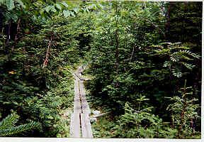
The Long Trail is a primitive "footpath in the wilderness." Although extensive work has recently begun to control erosion and bridge extremely wet areas, the Trail is for the most part "unimproved." By design, no effort has been made to provide artificial surfacing, switchbacks, and other amenities found on highly engineered trails. In the tradition of other early New England trails, the Long Trail is steep, boggy, and rugged. Hikers should plan accordingly.
In other words, don't say you weren't warned. I met a southbounder (Rockfish), when I was about 70 miles south of the Canadian border. He is a triple-crowner, but his knees were bothering him and he had a pulled hamstring muscle. We talked briefly, and we agreed that the Long Trail was, mile for mile, the roughest trail that either of us had ever hiked.
There are painfully long stretches that cannot really be hiked. They must be climbed (climbed up or climbed down). By this, I mean that hikers must ascend and descend steep rocks and cliff faces using roots, rocks, tree limbs and occasionally ladders. When the rocks are wet, the footing can be treacherous (I have a jagged 3 inch scar on my left forearm as a reminder).
I would recommend the Long Trail only to experienced and adventuresome hikers who are in good shape, have no physical impairments or limitations and who are seeking a genuine challenge. If you are just looking for a trail on which to spend a few leisurely weeks relaxing in the outdoors, there are others to choose from.
The Green Mountain Club charged fees of $6 per night for roughly 1/3 of the shelters on the Long Trail in 2002. This money is used for a variety of purposes, including land acquisition (about 10 percent of the treadway is still on private property), shelter maintenance, tools for trail work and salaries for Ridge Runners and Caretakers, whose responsbilities include maintaining the privies.
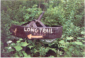
The Long Trail is marked with rectangular white blazes similar to the blazes that mark the route of the AT. Blazing was marginally adequate when I hiked. The GMC has developed some "creative blazing" techniques. This apparently involves cutting up the sides of bleach bottles into the proper size and shape and nailing them to trees (hey, it works!).
When I hiked in midsummer 2002, the area between Camel's Hump and Mt. Mansfield was quite crowded, even during the middle of the week. It was often necessary to scramble for shelter or tent spaces, and briefly wait in line to use privies and to get water.
One final note; I'd strongly recommend hiking the trail from south to north. This will provide an opportunity to strengthen the leg muscles and generally get into hiking shape (both physically, mentally and emotionally) before having to tackle the rough northern portion of the trail.
My Journal:
July 10 (Day 0) -
Brawny and I spent most of the day riding Vermont Transit Lines buses after leaving her car (The Blue Rocket) at a friend’s house near Waterbury, VT. We arrived in Williamstown, Massachusetts about 4:00 p.m. Brawny stopped a passing pedestrian and asked directions. When the young woman found out we wanted to go to the Appalachian Trail, she offered to give us a ride. A few minutes later, we were standing on Rt. 4 where the AT crosses the highway. We hiked about 2 miles and stopped for the day at Sherman Brook Campsite. Leaving Brawny to the challenge of putting up our non-freestanding Coleman Cobra tent on the tent platform, I quietly slipped away into the woods and found the nearby spring. When I returned with our water, our tent was standing tall and proud on the platform. The weather was beautiful, and so were the woods. It was great to be back in the woods with Brawny. We’d had a hectic 3 day trip to get here from our home in north Georgia. We both felt the tension of the long road trip slipping away as the beauty and quiet of the natural world took effect. We both spent a restful night.
July 11 (Day 1) -
We reached the Massachusetts – Vermont state line (and southern terminus of the Long Trail) an hour or so after leaving camp. We took our morning break and we both signed the register. This was Brawny’s first chance to catch up on “trail news” since she left the AT to come home a couple of weeks ago. I hiked this part of the Long Trail (southern terminus to Maine Junction) when I hiked the AT in 1992, but it looks a lot different now. It was late fall when I came through here 10 years ago. I have my old Kelty pack with me (same pack I had in 1992), but couldn’t think of a single other item of gear that I’d had with me in 1992. We hiked about 12 miles and stopped at Congdon Shelter. It looked the same as it did 10 years ago when Timbo, Polar Bear and I pulled in on a cold, rainy day. However, the wood stove had been removed. The patched wood floor directly under the area where the stove had been probably told the story of why it had been removed. Since the floor had been patched, probably the bottom of the stove had finally given way and emptied hot coals onto the bottom of the shelter. My body has started rebelling against another long distance hike. After 3 days sitting in vehicles and then one day of carrying a loaded backpack in the mountains, my lower back is putting on quite a show. I’ve got to take it easy for a couple of days, or this could be a very short hike.
July 12 (Day 2) -
I wanted to do a shorter day, but we more or less had to hike 14 miles to Goddard Shelter because of the shelter spacing and water. However, the beauty of this place was worth the effort. We arrived late and almost all tent spaces had been taken. We finally found a spot. Brawny and I have returned to our routine we developed on the PCT of her putting up our tent in the evenings while I get water for both of us. We were rushed a bit because of approaching darkness, but we relaxed as best we could while cooking our evening meals, enjoying being in camp together as well as the immense natural beauty that surrounded us. My back actually feels better after hiking 14 rough miles in the mountains with a fully loaded backpack. This is something I’ve come to expect, but I know that most doctors would tell me I need to go home and go to bed for a few days. It has been my experience that most doctors don’t hike.
July 13 (Day 3) -
We were both tired from yesterday. We hiked only 9 miles to Story Spring Shelter and camped in the tenting area. The trail is a bit rougher than I remember, with lots of rocks and roots to navigate. The bugs are bad, but the weather and scenery are beautiful. My back is holding its own, but I have several blisters, and the lower patellar tendon on my left knee is acting up a bit. Mostly normal stuff for making the transition from the Real World citizen to long distance hiker. Hopefully, it will pass. Brawny and I are really enjoying hiking this section together, however, it is in the back of both our minds that we will be parting soon. We don’t talk about it a lot, but its there. Sometimes, it seems that we are back on the PCT. When I am hiking and thinking of phone calls I need to make to folks at home, I find myself thinking about the 3 hour time difference between California and Georgia; then have to remind myself that we are hiking in Vermont, and there is no difference in the time zones.
July 14 (Day 4) -
Hiked up and over Stratton Mtn. and we had lunch at the fire tower. I felt strong today for the first time on this hike. Feel like I’m finally getting my trail legs back. We descended to Stratton Pond and decided not to spend $6 each to camp. Continued on to the Winhall River and found a nice little stealth site on the north side of the river and east side of the trail. About a half dozen hikers hiked to within 25 feet of our camp and didn’t notice that we were there. This is a beautiful place to camp, and we are very glad we didn’t stay at noisy and crowded Stratton Pond.
July 15 (Day 5) -
Got an early start and hiked to the road that goes to Manchester. We got a ride in about 10 minutes and had a very hectic resupply. Town was hot and very crowded. We gave up on using the Laundromat (it was packed), and settled for just buying trail food and getting a restaurant meal. Brawny saw a fellow thru-hiker (Greenbean) whose family had met her in town. They are very nice folks, and gave us a ride back to the trail. We hiked to Bromley Campsite and put up our tent just as a noisy thunderstorm hit. It is good to be back in the woods, and out of town. I guess we picked the wrong day to go into Manchester.
July 16 (Day 6) -
We hiked only about 10 miles and camped at Griffith Lake. There is supposed to be a $6 fee (each) for us to camp here, but no one came around to collect the fee, so we left without paying. Humidity around here is surprising. The temperatures are not that high, but it feels like we are hiking in a sauna.
July 17 (Day 7) -
We hiked about 10 miles to Homer Stone Brook and made a stealth camp. The Vermont woods are beautiful, and the trail has leveled off a bit. Bugs are awful; I think there is a small pond behind us. The days are beginning to take on a rhythm. We get up about 6:00 and get on the trail about 7:30. We then hike a leisurely 10 – 12 miles and camp between 4:00 and 5:00. We have plenty of time to get cleaned up, drink coffee, update our journals, plan the next day’s hike and eat supper. We are normally in our tent before dark. Brawny has been in a thru-hiker mindset for months, and I sense that it is a bit difficult for her to shift gears. I think she feels a bit “guilty” about the laid back hiking style, but it is obvious that we are both enjoying it. She’ll be back to 20 – 30 mile days soon enough.
July 18 (Day 8) -
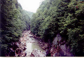
Hiked 12 hard miles to Clarendon Shelter. The trail on both sides of Clarendon Gorge is very steep and rough. There is a plaque on the gorge bridge dedicated to a young man who died here a number of years ago. It made me think of the 4 people I hiked with in 1992 who have since passed away. George Sayre died of cancer, Polar Bear was killed in an auto accident, Crazy Sweed couldn’t make the adjustment back to the Real World and committed suicide. In addition, Flicka Rodman (and his wife Jane) died while hiking the Pacific Crest Trail. As a group, I don’t think that long distance hikers have a great deal of longevity. I believe that this is partly because we are risk takers by nature. We take risks everyday that keep most folks at home. We laugh about bear encounters and dodging forest fires. We climb high passes in impossible weather conditions. We get out map and compass in a blinding snowstorm and try to figure out our route. We head into 30 mile stretches of desert in 105 degree heat with 5 quarts of water. And occasionally the odds catch up to one of us. It happens, but it is the kind of thing that most long distance hikers don’t like to talk about.
July 19 (Day 9) -
We hiked about 10 miles in threatening weather and arrived at Cooper Shelter atop Killington Mtn. a few minutes before rain started. We have a town day tomorrow after being out 10 nights, but we have mixed feelings about it. It also means the end of hiking together. The next morning, we will part company at Maine Junction. Brawny will turn east for Maine, and I’ll head north for Canada. Brawny will get an early start tomorrow and hike the official AT route to Maine Junction. She needs to get to the post office before it closes at 11:30 (Saturday hours) to mail home our 2-person tent, and to pick up our 2 solo tents. I will have the luxury of a slower pace, and intend to hike the old historic Long Trail route past Pico Camp. We will meet at the Long Trail Inn.
July 20 (Day 10) -
Brawny left about 5:00 a.m. (as soon as she could see to hike). I had coffee and breakfast and got on the trail about 6:30. I left the official route at the side trail that goes by Pico Camp. I spent a very enjoyable night there in 1992 watching a full moon come up over the mountains and valley, and wanted to see the place one more time. When I arrived at the Long Trail Inn at the highway, Carol had already been to the post office and had secured a room for us. After being out 10 days, we went to our room and crashed. Later, I resupplied in Killington and we had a great lunch at the Long Trail Inn. We had supper at McGrath’s Pub (also at the Inn) and there was live music. We spent the entire evening at the pub listening to the Irish music. Carol sipped her white wine, I had a couple of O’Douls and we had a very special time together that was quiet, romantic and very memorable. Neither of us wanted to think about parting at the junction the next morning.
July 21 (Day 11) -
Had a nice breakfast this morning at the Inn with 8 – 9 AT and Long Trail hikers. Later, Brawny and I parted at Maine Junction. It was difficult, but I know that she is anxious to finish her hike as a thru-hiker, and this parting was inevitable. I have no intention of re-hiking the 488 miles to Mt. Katahdin. Our plan is for her to hike as fast as she can without getting hurt. I will have the luxury of a slower hike and I’ll do moderate mileage. If it turns out the way we’ve planned, I’ll finish 7 – 10 days before she does. I’ll get from Canada back to the car at Waterbury, VT the best way I can and then I’ll support the rest of her AT hike. We probably will see each other again in Caratunk or Monson, but that is a long way down the trail for both of us. We said our good-byes and shared an embrace and a kiss. I stayed at the junction while she walked away. I stayed until she was out of sight, then turned north on the Long Trail, bound for Canada one more time.
I had to choose between a 4 mile day and a 12 mile day because of the shelter and water spacing. Reluctantly, I opted for the 12 miles. Because of our late start, I didn’t arrive until about 7:00. I put up my tent and camped near the spring and the shelter. I missed Brawny terribly; camping alone after we had been hiking together seemed very lonely. Later, a couple (Fiddlehead & Lambswool) and another hiker (Saturday Nite) came in. All 3 are Long Trail thru-hikers, and I’d met them at breakfast at the Inn earlier in the day.
July 22 (Day 12) -
Another rough day. They didn’t name it Horrid Mtn. for nothing, and it lived up to its name. Hiked about 12 miles to Sucker Brook Shelter. Trail maintenance sure did change after Maine Junction. Hiked for miles through stinging nettles that leaned in on the treadway from both sides. I’m pretty well scratched up. Coming into contact with nettles makes a person feel like they’ve been bitten by a multitude of tiny insects. They itch like crazy and the stickers can (and did) break the skin.
July 23 (Day 13) -
Hiked about 12 miles to Proctor Shelter in rain, wind, fog and cooling temperatures. Now wearing Thermax while sitting in my 30 degree goosedown sleeping bag. A storm is howling outside the shelter, but I’m warm and dry inside. Hot coffee is a special treat. Temperature has dropped about 30 degrees since this morning. I had felt kind of foolish carrying this Thermax clothing in all the heat, but I knew something like this was likely to happen in the mountains so far north. Right now, I’m very thankful for this sleeping bag and every piece of warm weather clothing I have. I learned my lesson years ago when I had a brush with hypothermia on the AT in Georgia during the third week of August. When I go into the mountains now, I go prepared.
July 24 (Day 14) -
Awoke to cool and clear weather. The storm mercifully reduced the humidity level. Hiked about 12 miles to Battell Shelter, and it is very crowded. There is very limited tent camping and all the sites are taken. Had no choice except to sleep in the shelter with 7 – 8 others; it was elbow to elbow. A young man came in with two of his children, a girl about 6 and a boy about 5. They were out for their first backpacking trip. I've often said that I'm old enough to be the father of most hikers I see out here. Now, apparently I'm old enough to be the grandfather of a few of them, too. The father had brought way too much food, and he graciously shared it with the LT hikers who were around. Honest to god, he'd packed in a 5-pound brick of cheese. We whittled it down until he finally called a halt, saying he needed a bit for breakfast. What are two hungry little children to a group of starving hikers??
July 25 (Day 15) -
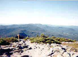
Hiked up and over Mt. Abraham, briefly going into the alpine zone in the process. I have a long history of bad luck in alpine zones. I briefly thought back to previous avalanches, blizzards, white-outs, rock slides, 90 mph winds, broken bones and bouts with hypothermia. I am a 3-season hiker and make no apology for it. However, the view from the summit was truly spectacular. Many thanks to those who fought to keep the ski-industry off the mountain. The industry must have put up a heck of a fight, backed by big bucks and politicians who had been bought and paid for. In several areas today, it was necessary to climb up and down steep rocks, using whatever hand-holds could be found. Also, counted 24 blowdowns in the afternoon. For several of them, I had to remove my pack, go under them, and drag my pack after me. So far, though, my back and knees are holding up. Hiked about 12 miles to Birch Glen Shelter.
July 26 (Day 16) -
Decided to do a relatively short day and hiked only 8 miles to Montclair Shelter. I really have no incentive to hike fast. Regardless of how slow I hike I’ll finish before Brawny (when we parted at Maine Junction, she had 488 miles to hike, I had only about 160). It costs me nothing (or very little) to stay in the woods, but it will cost me at least $40 - $50 per day to stay in town after I finish my hike. Sharing the shelter with two local women who are out for a few days. The younger of the two has an external frame pack. When I asked her why she used an external frame, she said that all the internal frame models hurt her back. I told her that they all hurt my back, too, and that I’d heard similar statements from others who use the “old fashioned” packs (someone actually called them that!). Weather has turned cool and rainy.
July 27 (Day 17) -
Made the ascent to Camel’s Hump in fog, rain and 40 – 50 mph wind, reluctantly entering the alpine zone once more. The footing was treacherous on the ascent, and I didn’t even want to think about descending the wet rocks I knew awaited me on the other side of the mountain. I took it slow and easy and made it to the summit without incident. There was no one else there and visibility was down to only 20 – 30 feet. I thanked whoever had painted all the white blazes on the rocks. The wind really picked up and I knew I’d be out of the wind once I got on the north side of the mountain, so I didn’t stop at the summit. I started having problems with traction on the wet rocks as soon as I started descending. While climbing down one particular steep section of bare rock, a foot slipped. I slipped down the rock face about 5 feet before coming to an abrupt stop on a ledge. Except for the small ledge, I probably would have sailed out into oblivion. As it was, I had tweaked a knee a bit and skinned my finger tips. There was another 75 ft. section of steep descent still to be done. I slowed down and tried to remain totally focused. I made it.
A few minutes later, while walking on a section of trail that was not particularly steep or treacherous, my left foot slipped badly and went out in front of me. My foot went forward with such velocity that I knew that there was no way that I could avoid falling down onto the bare rocks. I was falling straight back, and I could feel my right leg getting caught under my body. Visions of a Joe Theisman-type injury flashed through my mind (for non-football fans, Joe Theisman is a former quarterback for the Washington Redskins. An opposing player fell on him during a game, and he got his leg caught under him when he went down. He suffered a particularly gruesome compound fracture in front of a national TV audience on Monday Night Football and never played again). I also thought of my back; particularly of my tailbone and the bundle of nerves at the base of the spine. If I fell straight back and impacted the area of my back that was already injured, I might not walk out of here (or anywhere else ever again). I tried to pivot on my right knee, and push to the left with my hiking poles. Things were happening fast, but the tactic worked. I was able to turn my falling body slightly to the left, and just before I hit, I managed to get my right leg out in front of me. That was the good news. However, I cried out in pain as the body parts that had been sacrificed (left arm and left leg), crashed into the rocks.
I hit on my left side, and then rolled over onto my back. I knew I was hurt, but didn’t know how badly. A blinding jolt of pain had struck in the vicinity of my left elbow. I would worry about that in a minute. I checked my knees; no pain, no problems. I then checked my lower back; all okay. I knew my left hip was scraped up pretty badly, but it didn’t feel serious. My attention turned to my left arm, and I found that I could barely move it. And blood on the rocks once more. I hadn’t had so much fun since I nearly took a dive off Mt. Whitney in 1999. I touched my right hand to my left elbow and it came back covered with blood. My first instinct was to take off my pack, but I thought better of it. If I took it off, I might not be able to lift it back on. So, using my legs and right arm, I managed to stand up. I seemed to slowly be getting more use of my left arm, but at that point I thought that my hike was over, it was just a matter of being able to walk out or having to be rescued. I needed a spot to stop for a while, stand my pack up against a tree or rock and sit down and lean against it, but there was nothing but bare rock around. I kept hiking and found a place to stop after about 10 minutes.
I leaned my pack up against a tree and got out my first-aid kit, water bottle, bandana, cell phone and some snacks. I tried the phone and it still worked. The signal was weak but adequate. I could make a 911 call if I had to. I turned off the phone and turned my attention to my left arm. I was bleeding pretty badly, and I couldn’t lift my arm high enough to see the elbow area. So, I bent the arm and lifted it up with my right arm. At first, it was just a bloody mess. However, I irrigated it with purified drinking water and dried it with my bandana. There was a lot of scraping, and at the middle of all the road-rash (trail-rash?) was a fairly deep and jagged 3 ¼ inch cut. I put some hydrogen peroxide on a cotton ball and cleaned the wound. When I was done with that, I cleaned my right hand with alcohol and a cotton ball and applied direct pressure to the wound with my right hand. After about 10 minutes, the bleeding had stopped. I put iodine and antibiotic cream on the wound, then tried to relax and had some snacks.
Range of motion was returning to my left arm. I could move it and even make a fist, but not a tight fist. However, I could lightly grip my hiking pole, so I decided to try and hike out. After a few minutes, I was moving along pretty well. My arm worked well enough, but I couldn’t put much weight on it. However, it started bleeding again. I stopped again and tried to get the bleeding under control. It was at that point that trail angel Carlene and her dog Jackson came around the bend.
Carlene lives in the nearby town of Jonesville, and she is a member of the Green Mountain Club. She and Jackson were out on a day-hike. We talked for a while, and she noticed my injuries and asked me how badly I was hurt. I told her that I really didn’t know yet. She asked me if I needed to go to a hospital and I said that I didn’t think so, but right now my main objective was just hiking out to the road (Rt. 2 to Jonesville). She offered me the use of her back yard for camping that night and said she had a first-aid kit at home. She also graciously offered to prepare a steak dinner for me, wash my clothes and drive me to nearby Richmond to resupply. She offered to wait for me at the highway and drive me to her home, but there are 3 miles of the Long Trail that are on Rt. 2 (to get hikers over the Winooski River). I thanked her, but said I’d try to hike the 3 miles on the road. She smiled and said that I must be a purist. I managed a smile and said that I wasn’t exactly a purist, but I wasn’t up to yellow blazing, either. She gave me directions to her house and resumed her hike.
A few hours later, I showed up at her front door. I put my tent up on her back lawn and she allowed me to come inside to get a shower. Afterwards, she washed my hiking clothes and true to her word, took me shopping in Richmond, and then prepared a steak dinner for me on her back deck. This was some of the best, most timely and appreciated trail magic that I’ve ever experienced, and I will never forget it. The next morning, she drove me to the north side of the Winooski River (the bridge is out and is being rebuilt). I’d touched the barricades on the south side of the bridge the day before, and tagged the barricades on the north side of the bridge the next morning. I was still a “continuist”.
July 28 (Day 18) -
My left arm is awfully banged up, but it is much better. I have full range of motion, and it will support about half of its normal weight load. It is swollen, bruised and scabbing over, but I don’t think I broke any bones. After Carlene dropped me off at the Jonesville General Store, I bought some coffee and a few other items I needed. I then hiked about 7 miles to Buchanan Shelter. I put up my tent and shared the campsite with a group of young French Canadians from Quebec. There are 2 adult counselors (Nick and Domenic) 3 teen-age boys (Gavin, Eric and Julienne) and 2 girls (Mary Ann and Marylease). They are a great group and whether they know it or not, they are helping to keep my spirits up. That little adventure yesterday on Camel’s Hump nearly put me off the trail.
There was kind of a strange character in the shelter when we arrived, and everyone opted to put up their tents. The guy set everyone’s radar off, including mine. One of the teen-age boys took an interest in my gear and my previous hikes and visited me while I was cooking supper. He mentioned the weird-acting person in the shelter and told me not to worry, that he’d had military training (Junior ROTC) in school, and that he’d protect us, if needed. I looked up and saw that he was dead serious. I just smiled faintly and nodded. He then asked me if I’d taken ROTC in high school, and I told him I hadn’t. He smiled and nodded. After a few seconds passed, I added, almost as an afterthought, “But I did spend a year in Viet Nam with the 25th Infantry Division a long time before you were born”.
We all had a quiet night. The guy in the shelter behaved. However, when some late arrivers got to the shelter, he moved out to one of the tenting platforms after dark and in the rain, although he didn’t have a tent or sleeping bag.
July 29 (Day 19) -
Hiked just over 10 miles to Twin Brooks Tenting Area. Had rain last night and this morning and rocks were treacherous. Descended a 40 – 45 ft. ladder down the side of a cliff. Getting frustrated with the obstacle course that is passed off as a “trail”. Calling it a trail indicates that it can be hiked, and that is not true. A good part of the northern section must be climbed. The trail goes up one side of a steep mountain over nearly vertical slabs of rock, then down the other. I’m still leap-frogging with the young French Canadians. I enjoy their company and also the songs that they sing in French as they hike. I slipped again today on wet roots, but fell into soft dirt and vegetation. Wiped out a few ferns, but no other casualties. My left arm feels better and stronger, and the wound is healing nicely.
The teen-age Canadian boys and their young male counselor seem to be competing with each other concerning hiking speed. They pass me numerous times going full-speed uphill. They get out of breath and have to stop, and I pass them. Then, instead of competing with each other, they start competing with me. The last time I passed them after they were all out of breath, they went even faster and then got out of breath even sooner. With my moderate and steady pace, I passed them again and I wasn’t even breathing hard. I couldn’t understand their French, but it was obvious they were saying something like, “How does this old guy keep passing us??” Different generation, different hiking style.
July 30 (Day 20) -
It rained very hard about 4:00 a.m., everything got soaked. I’d gone to sleep and left my little radio by the door of my tent. It may be ruined. That radio has been a welcome part of my camping routine since Brawny and I parted at Maine Junction. After I eat and wash the dish, I get into my tent and listen to a great oldies station (K105) out of Burlington. Began making my ascent of Mt. Mansfield. Met some southbounders and they told me that the winds near the summit were gale force and increasing. They said that by the time I got there, it could be really bad. They also said it was foggy and there were no views. They mentioned the bad weather bypass around The Forehead, and they suggested that I consider it. I thanked them for their consideration and suggestion. They were right. I took the bypass and found that I was back among the trees and off the barren rock. The wind decreased. However, basically I was now ascending a cascading waterfall. The “trail” went up slabs of rock at a steep angle, twisting and turning. However, because of the rainfall earlier in the morning, water was pouring down the trail. I made a wild guess that the rocks were going to be wet. I’ll say one thing about the Long Trail. I learned a lot about walking on wet rocks. I have 4 points of contact with the trail; 2 legs and 2 poles. I began hiking in such a way that I have 3 points of contact at all times. Only one foot or one pole is off the ground at once. This method of walking forces me to slow down and concentrate. Also, I’ve learned to check the rocks carefully for any little crack, crevice or ridge that will give me a bit of extra traction. In a bad section, I plan my entire route (to the next point of relative safety), not just the first few steps. When I began ascending the cascading waterfall, I put all this theory into practice. I was very happy to see that it worked. I didn’t slip once on the side trail, even though I was walking on steep rocks covered with water with each step. I tried not to think about how far I’d slide down the rocks if I slipped. I’d be careening around, bouncing off rocks and trees like a pin-ball.
After the slip and fall that injured my arm, I tried to think logically about what had happened and to find a way to keep it from happening again. I reasoned that folks have hiked this trail in all kinds of weather conditions; from rain to sleet to ice and snow. Apparently every section of trail has been hiked successfully in every conceivable type of weather. Therefore, I concluded that if I slip, it is because I made a mistake. If other people have made it, I should be able to make it, too. Therefore, I concluded that I needed to hike on the wet rocks without making mistakes. I needed to stay focused, slow down, and stay calm. I would hike confidently and would not allow myself the luxury of anger, fear or frustration if I got into a bad situation. It was working.
Soon, I was out on open rocks and back on the official route. The winds were really bad, probably about 60 – 70 mph. Several times, they knocked me off balance. I met an official looking person in a green uniform and he suggested that I take another bad weather route, the Profanity Trail. Glibly, I wondered, “Why do they call it the Profanity Trail?” Before I got to the next alternative route, I was getting into some really bad wind gusts. Several times I had to stop and wait for the gusts to subside. Instead of just being knocked off balance, now I was getting knocked down. I remembered my broken wrist in the White Mtns. in 1992 in similar conditions. I thought (too late) to reach around and check my pack cover. It was gone. I briefly backtracked to try and locate it. However, the absurdity of trying to find a small, black sail on an extremely foggy day in 70 mph winds soon dawned on me. I accepted the fact that my pack cover was gone and continued my hike.
Finally I reached the turn off that was the Profanity Trail, the bypass around “The Chin”. A few minutes later, I had my answer concerning why it has the name it does. I was cursing it, too. This “trail” went straight down the side of the mountain. There were endless nearly sheer sections of 10 – 20 feet each. I knew that with one slip, my hike would be over. It also dawned on me that I was on a side trail, and that if I got hurt, it could be a long time before anyone else came along. It took me over an hour to hike this trail, which probably is no more than about a half mile in length. Finally, I was back on the main route, and just below the summit of “The Chin” on Mt. Mansfield. There is a large GMC lodge there (I don’t recall the name of it), and I stopped for lunch. I noticed that it took a lot of effort to figure out simple things like deciding where to put my pack, where I was going to sit, opening my pack, and getting out my food and water. I just wanted to sit and stare. I suppose I was in a mild state of shock from the day’s activities. I had lunch and felt better in about a half hour. Later, I managed to make it to Sterling Pond Shelter. The weather had cleared and the area around the pond is beautiful. There are two shelters there, and I had one of them all to myself. I cleaned up, relaxed, ate a leisurely supper and went to bed. I was very glad to see that my little Sony Walkman radio still worked. However, each time I closed my eyes, I’d see some impossible ascent or descent on Mt. Mansfield and could practically feel the 70 mph wind on my face. I didn’t sleep well, but at least I hadn’t received any additional injuries. I am about ready to wrap up this little adventure and go home. Because of the alternative routes, I'm not sure how far I hiked, but it was probably about 15 miles.
July 31 (Day 21) -
The climb up (and down) Whiteface Mtn. was one of the roughest I encountered, but mercifully the rocks were dry and there was lots of stuff to hang onto. Hiked about 8.5 miles to Bear Hollow Shelter. I hope that the worst of the trail is now behind me. I’m only 54 miles from the Canadian border. I’m going into town tomorrow to make my last resupply stop, which will be in Johnson. A southbounder named Jason came in just before dark and he and I talked a while. He delivered a written message to me from Lambswool & Fiddlehead, and I thanked him for it. They had blue-blazed ahead, said they regretted that we wouldn’t be able to hike together anymore, and asked me to stay in touch. While Jason was getting water out of the spring that is just below the shelter, I heard a commotion. When he got back to camp, he said that a deer had run right past him with a coyote in hot pursuit. I told him that he was very fortunate, that I’d spent many years outdoors and hadn’t seen anything like that.
August 1 (Day 22) -
Turned 55 on the trail. Mainly because of my back and knee problems, when I turned 45 on the AT in 1992 during my thru-hike I never dreamed that I’d still be able to do this type thing 10 years later. However, I’m hiking lighter and smarter now. Maybe if I keep it up, I’ll still be out here bucking the odds on my 65th birthday in 2012.
Hiked about 4 miles (including a 1 mile roadwalk) to the point where the trail turns left off the main road at The Long Trail Tavern. At that point, I hitched into Johnson and resupplied at the large supermarket. Johnson is a pretty good trail town for LT hikers who just want to resupply and get out without spending the night. In addition to the supermarket, there is a drugstore, public phone and 2 laundramats, all within a couple of minute’s walking distance of each other.
After resupplying, washing clothes and making phone calls, I considered my options for getting back to the trail. The bank thermometer read 92 degrees, and I didn’t like the idea of getting out on the highway and hitching back to the trail. Since it was my birthday, I decided to give myself a treat and try to yogi a ride back to the trail at the same time. I got a pint of Ben & Jerry’s ice cream and positioned myself and my pack about 20 feet from the doors of the very busy supermarket. My plan was to continue eating ice cream until one of the kind, gracious and generous Vermonters offered me a ride back to the trail. I was prepared to eat a minimum of 3 pints of ice cream. If I was still sitting in front of the grocery store after 3 pints, I’d try to come up with a Plan B. However, just as I was finishing off pint #1, I saw a lean, healthy, bearded man come out of the store. I figured he was a hiker, biker or runner or maybe all 3. Could also be a teacher or professor at the local college. He walked up, smiled, and asked if I needed a ride back to the trail. Bingo! I said that I did, and he gave me a ride. I noticed the bike rack on his car, and he mentioned that he and his wife loved working with young folks, that they often took large groups out on the local trails.
Brawny and I have been staying in touch by leaving Voice Mail messages on each other’s phones. I picked up her messages and left one for her. We are both more or less on schedule. It looks like we will be able to get together either in Caratunk or Monson. After I finish my hike and get back to the car, I’ll drive to Maine and track her down.
I’m only about 44 miles from the border, and could finish the trail in 4 days, except for the shelter spacing. The rest of the way, I’ll have to choose between short days (6 – 7 miles) and long days (12 – 14 miles). Therefore, it may take me almost a week to finish. In this section, the trail is on private land and hikers are required to camp only at shelters. Many hikers blame the GMC for the spacing of the shelters, but being a maintainer myself, I know that the shelters are where they are because of the water sources, and not because of poor planning.
After hitching back to the trail, I hiked 3.6 miles to beautiful Round Top Shelter. I was concerned about finding water at the top of the mountain (where the shelter is located), but there is a water pump about 1/4 mile below the summit. I had all the water I needed, and found a beautiful little campsite just below the shelter. I had the place all to myself. I figured that there would be far fewer folks on the trail now since I was out of the popular Camel’s Hump – Mt. Mansfield area. My wounds are healing nicely, my back and knees are holding up, the crowds are gone, I am resupplied, and I am within striking distance of the Canadian border. Things are looking up.
August 2 (Day 23) -
Hiked about 8 miles to Corliss Shelter. The alternative was doing 15 miles, which would have really been pushing it in this terrain. At my lunch stop, I had a view of Camel’s Hump and Mt. Mansfield. Generally, when viewed from the south, Camel’s Hump has one hump, but when viewed from the north, two humps are visible. Personally, I think they should have named it Mt. Parton. Just kidding!
Anyway, I’ll be glad when Camel’s Hump is no longer visible. Makes my arm hurt when I see it. Also, I can’t help but wonder if my pack cover is still somewhere on Mt. Mansfield blowing around. Maybe it made it all the way to the White Mtns., or maybe even to the Atlantic Ocean.
This section of the LT is definitely less crowded. Just had a full 24-hour day when I saw no one else on the trail at all.
August 3 (Day 24) -
Hiked only 7 miles to Spruce Ledge Shelter and camped about 25 ft. from the shelter, up on a little knoll. There are only a few skinny little trees and bushes between me and the shelter, however, a southbounder came in later, looked my way, walked into the shelter but gave no indication that he’d seen me or my tent. To avoid any surprises (some hikers have Mace, black-belts and a few even have guns), I started whistling and even coughed a couple of times to let him know I was close by. Immediately, he came out of the shelter to see where the noise was coming from. It was hard to believe that he hadn’t seen me. Stealth colors are really something. He came back and we talked for a while. He is Irish by birth and immigrated to the US when he was 14. He saw the Northern Ireland patch on my pack and asked if I’d actually been to Northern Ireland. I told him that I had, and we talked about Ireland for a good long while. Later, another southbounder came in, a 58 year old woman. The trail had beaten her up pretty badly, and she was planning on getting off the trail for a couple of days at Johnson. I have a feeling she’ll come back and finish, though.
I’m trying to enjoy these last few days on the trail, but I’m anxious to finish. Looking north, I can see into Canada. I should be there in 3 days. I feel good and have plenty of coffee, food and fuel. The weather is warm and buggy, but nice. Going to hike across that border one more time.
August 4 (Day 25) -
Hiked 14 tough, steep and rocky miles to Hazen’s Notch Shelter. I have a difficult time remembering the name and have been mentally referring to it as Haagen-Daas Shelter. I didn’t arrive until about 7:00, barely had time to put up my tent, clean up, cook, eat and wash the dish before dark. I didn’t even listen to my radio after I got into my tent, though I’m still getting good reception from K105 in Burlington. Took 3 Ibuprofen, and passed out quietly.
August 5 (Day 26) -
Climbed up and over Jay Mtn. It was very cool, windy and foggy near the summit, and I had only limited views. Rain is coming, and I’m concerned about footing on wet rocks. I’m anxious to make as many miles as I can before the rain starts. However, some southbounders told me that there was no water at Shooting Star Shelter, so I stopped at Laura Woodward Shelter after only 8 miles. However, another southbounder was at Laura Woodward Shelter. He said that even though there was no spring or creek directly at Shooting Star Shelter, that there was a great water pump about ¼ mile south of it just off the LT. I thanked him, dumped my water and headed off, planning to hike another 4 miles even if I got caught in a thunderstorm. This would put me only 4 miles from the border, instead of 8. That will mean I will finish much earlier in the day tomorrow, which will give me lots more daylight to get to civilization and maybe even to Newport, where I have to catch a bus. Even though the weather was threatening and there was thunder in the distance, I made it to Shooting Star Shelter about 7:00 without getting caught in a thunderstorm.
I had the beautiful shelter all to myself. There is indeed a water pump exactly where the southbounder told me it is, and I got all the water I needed. I really enjoyed my last night on the trail. I had lots of coffee (no need to conserve fuel now!) and a nice leisurely supper. I relaxed and took my time, even though I was running out of daylight. I went to sleep listening to oldies on K105 and the sound of the rain hitting the metal roof of the shelter.
August 6 (Day 27) -
I was up and on the trail a bit earlier than usual. I knew the rocks were going to be wet and treacherous all the way to the border, and that my pace would barely be 1 mph. I’d be using my 3-point stance method of hiking on the steep sections, and this really slows me down. I also knew that no matter how close to the border I was, I still had plenty of time to break a leg or ankle.
I reached the border about 1:00. A southbounder had told me that the border was very evident, but that I’d have to look around a bit for the metal marker that is the northern terminus of the Long Trail. He was right. The marker is out of sight (when standing at the border), just below some rocks. I raised my fist above my head one more time, and bent and kissed the marker. There was no one else around at all, and I didn’t remain at the border long. I briefly walked around in Canada for a minute, then got back on the US side and found the blue-blaze trail that I’d need to get back to civilization.
After just over a mile of walking, I came to Journey’s End Shelter. I cleaned up a bit and changed clothes, knowing that I’d be hitchhiking soon. I walked what seemed like another mile and finally came out on a gravel and dirt road. Using the directions in the guidebook and my compass, I navigated toward the town of North Troy. Not long after I began seeing the first signs of civilization (a power line and a few cows), an officer of the border patrol drove up and stopped me on the road. He asked the usual questions, but let me go without checking my ID. I didn’t mind that he’d stopped me, and didn’t mind answering his questions. However, what really bothered me was the fact that he turned around and drove back toward town without offering me a ride. An hour later, I was in North Troy. I hitch-hiked to Newport and found the bus station. My bus to Waterbury (where the car was parked) would leave at 7:15 the next morning. I checked into the motel across the street, and an hour later I was relaxing in the hot tub with a cold soda, watching the thunderstorm that was raging outside.
Afterword (Driving To Maine & Locating Brawny):
I really crashed when I got to the motel room in Newport. For some reason, I wanted to get everything off my body (not only my pack, but clothes, Timex watch and even the Photon light and whistle I carry on a lanyard around my neck). Next, a nice hot shower, then a cooler shower and then into the hot tub. Finally, I began to unwind. Later, I washed all my clothes at the motel coin laundry and went back to the store for a few items to eat in my room for dinner. Then I locked the door, turned on all the lights and the TV and closed the drapes. Let the outdoor world stay outside where it belongs! I am in for the night! I didn't go out again until I went to breakfast at the diner across the street the next morning.
I was out of the room and at the bus station / general store about 6:45 the next morning. The bus was a few minutes late. An LT thru-hiker (Craig) who was about to begin his hike was also waiting for the bus. He had left his car near the northern end of the trail, and was going to Williamstown to begin his hike. We talked for several hours about hiking, gear and life while riding through the beautiful Vermont and New Hampshire countryside. It was very nice having another hiker to talk with, and we had a very enjoyable conversation. By this time, I knew my way around Vermont. When I changed buses in White River Junction for Waterbury, I belive it was the 3rd or 4th time I'd been there. The bus arrived in Waterbury about 4:00 and I was only 2 1/2 miles from the car. I could have hitched, but decided to walk. Just over an hour later, I walked up our friend's driveway and there sat Brawny's Blue Rocket. Our friend was still away on a hike, so no one was at home. The good news was that the car was there and intact; no vandalism or damage of any kind. The bad news was that the battery was dead. I considered my options. There were jumper cables in the trunk. There was another house about 1/4 mile away on the road, and I had no choice except to walk back to the road and ask the woman who lived there if she'd drive up and allow me to use the jumper cables on her car. After I explained the situation, she surprisingly agreed. Only in Vermont, I told myself. A few minutes later, the Blue Rocket was fired up and purring like a kitten, ready to go to Maine and find its owner. I thanked our friend's neighbor (Cindy) profusely. I offered to pay her, but she wouldn't take a cent. Like I said, only in Vermont.
My pack was in the back seat, I had sodas and snacks in the front seat, and Rod Stewart was blaring about Maggie May on the tape player. Oh, how good all this felt! I planned to drive to Rangely, Maine and spend the night at the Horse Feathers Inn. I'd spent the night there during my 1992 AT thru-hike, and had been looking forward to seeing Mac and JoAnn again. However, when I got there, neither Mac or JoAnn was around, and I noticed the non-hiker nightly rate of $60 per night posted on the front porch. Reluctantly, I got back in the car and continued driving. As it turned out, it was a very long night. I knew Brawny would probably be in Caratunk the next day and I planned to meet her there. I decided to drive toward Caratunk, knowing that the later it got, the less chance I'd have of finding reasonably priced lodging.
This night finally ended in Caratunk at 2:30 a.m. Exhausted, I found a small stretch of woods on the road to town (off the main highway). I pulled over, locked all the doors, left the keys in the ignition, put the passenger side seat all the way back, and got a few hours sleep.
When it got daylight, I started driving around to acquaint myself with the area. I found the AT parking lot that I couldn't locate the night before. I found the post office and the Northern Outdoors Rafting Center (with restaurant) and wanted to have breakfast, but the place was bedlam. It was too much noise, so I decided to drive back to the AT parking area and come back later. I walked north on the trail a bit, then decided to walk south to the Kennebec River to kill some time.
I leisurely walked down to the river and could hardly believe my eyes. I looked again to make sure. Sure enough, on the far side of the river, repacking her things in her silnylon pack and waiting for the 9:00 a.m. canoe shuttle, was Brawny.
At first, she had trouble believing it was really me. She thought it was just some southbounder waving and yelling at her across the river. Communication was poor at best, but I finally convinced her that it was really me. At that point, she had ideas of trying to ford the river, but I suggested that she wait for the shuttle. Rather than stare at each other across the river for an hour, I decided to go back to the restaurant for breakfast. I got back to the Kennebec just as she was coming across in the canoe. Our period of separation was over once more, and we couldn't believe our good fortune in finding each other so easily.
We rented at cabin near Steve Longley's store (Steve runs the canoe shuttle, taking hikers across the river) and had a nice chat with Lion Heart, who works there. We spent a very relaxing day and night at the cabin, and had a great dinner at the Northern Outdoors restaurant. Brawny wanted to slackpack the 36 miles between Caratunk and Monson in one day, so I took her to the trail the next morning as soon as it was light enough for her to hike. We said our good-byes, knowing that we'd be together again late that afternoon.
I went back to the room and got some more sleep. Later, I checked out of the cabin and went for breakfast at the restaurant, then drove to Monson. I got a room for us at The Pie Lady's house. I drove to the AT about 6:00 and Brawny was waiting. She said she'd been there about 10 minutes. She'd done it! 36 miles in one day!
Later, we discussed The Wilderness that was just ahead (between Monson and Abol Bridge). It is about 100 miles in length. Brawny felt she could hike it in 4 days, and I told her that I thought she could do it, too. The next morning, I took her back to the trail and we said good-bye once more. I planned to meet her at Abol Bridge.
I spent the next 3 nights in Monson resting, catching up on my journal, talking with other hikers, eating, taking walks on the AT and watching TV. On the 4th day after taking Brawny back to the trail, I drove to Millinocket and secured a motel room at the Pamola Motel, where Timbo, Pastaman and I had spent the night after dragging our half frozen bodies off Katahdin in a near-blizzard on Oct. 25, 1992. I drove to Abol Bridge and saw a thru-hiker, Christopher Robin, in the store. I asked him about Brawny, and he said she should be in shortly, that she was fine and that he'd seen her the day before. She hiked in about 2:00, having successfully hiked the 100 mile Wilderness in 4 days. A few minutes later, we were on our way to Millinocket.
We were up at 3:30 the next morning (August 14), so that Brawny could get back on the trail as soon as it was daylight. She planned to hike the 10 miles to Katahdin Stream Campground, then climb Katahdin and come back down to the campground the same day. We had discussed it and we both felt that she could do it (we wanted to come home!). After I put her on the trail, I went back to Millinocket and got a few more hours sleep in the motel room. After I checked out of the room, I killed some time (mostly eating ice cream and drinking coffee), then drove to Katahdin Stream Campground in Baxter State Park. When I arrived at the campground, I could hardly believe all the people who were there. When I was there in October 1992, no one else was there, except for the 2 guys I was hiking with. Even the Ranger Station had been closed. I checked the register and found that Brawny had arrived shortly before 9:00. I figured she'd be down off the mountain and back at the campground about 2:00. Shortly after 2:00, she arrived. She retrieved her hiking poles from the porch of the ranger station. We pointed the Blue Rocket's nose south and began the long drive home.
A few hours later, the reality that she'd achieved her dream of thru-hiking the Appalachian Trail began to sink in. We spent the night in Gorham, NH and the next night was spent in northern Virginia. We arrived home safely the night of August 16. We were very tired, but thankful that our little home in the mountains was intact and waiting for us. We were also thankful that we'd both completed our hikes, and that the logistics had come together almost exactly as we'd planned.
We aren't sure what the future holds concerning other hikes and adventures. It is a bit difficult to plan another long hike at the present time. However, the Colorado Trail is a possibility; maybe even a section hike of the Continental Divide Trail. I've wanted to take a 500 mile canoe trip on the Yukon River for as long as I can remember, and that prospect is appealing to Brawny as well. So, we'll see. Right now, though, its just great to be home.
Rainmaker
August 23, 2002
Getting There (And Getting Out):
It is doubtful that those from out of state (who aren't driving their own vehicle) will be able to get to and from the trail without using Vermont Transit Lines (bus service). To see their web site (with fares, schedules, etc.), click here . Their phone number is 800.552.8737. Vermont Transit Lines (in my opinion) is somewhat expensive, but when I used their services in 2002, I found the buses to be clean, the drivers to be more or less courteous and they were almost always on time.
They provide connecting service from local airports, including Boston's Logan Airport. If you are starting on the southern end of the Long Trail, you'll need to take a bus to Williamstown, Massachusetts. The bus arrives about 4:00 p.m. From there, you can walk or hitch-hike on Rt. 4 a couple of miles east to the AT. There is a nice camping area (Sherman Brook) about 2 miles north on the AT. From there, the southern terminus of the Long Trail is about 3 miles north. There is also rail service to White River Junction, Vermont. You can catch a Vermont Transit Lines Bus in White River Junction that will take you to Williamstown.
Getting out on the northern end is a bit more difficult. After completing the Long Trail at the Canadian border, you'll need to take a side trail (perhaps 2 miles in length) that comes out on a gravel road a few miles from North Troy, VT. If you need to secure transportation, you'll need to walk or hitch to North Troy. Unfortunately, there is no longer any bus service or public transportation of any kind north of Burlington. However, there is a shuttle service. In March 2007, the cost of a shuttle from North Troy to Burlington was $95. For additional information concerning the shuttle, call Rose Apple Acres Farm in North Troy at 802.988.4300. If anyone has any additional information concerning transportation that is available from (or to) the northern terminus of the Long Trail, please let me know and I'll post it here.
Additional Info & Guidebooks:
The guidebook that almost everyone uses is available from the Green Mountain Club. Their phone number is 802.244.7037. To see their web site, click here .