My Home Page / CDT TrailQuest / Brawny's CDT Page
My ebooks The Passion Killers, A Dark Wind of Vengeance, Blood Beyond the Abyss and The Second Layer of Hell (apocalyptic fiction) are now available for download. They are the first four installments in the Path of Survival series. To see additional information, click here .
David "Rainmaker" Mauldin's 2004 CDT Hike
(To see my page for my 2003 CDT Hike, click here .)
"In the end, you find that no one wins, and that the race was only with yourself"
--Unknown
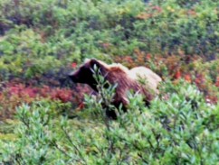
(Grizzly photo by David Mauldin)
rainmaker@trailquest.net
Foreword
This year, Carol and I hiked about 350 miles on our CDT route, from the Canadian border at Chief Mountain in Glacier National Park to just south of Helena, Montana.
In addition to hiking 8 days and about 100 miles in Glacier National Park, we also hiked through the Bob Marshall Wilderness and the Scapegoat Wilderness. In the process, we passed through the heaviest concentration of Grizzly bears in the Lower 48. However, we had no problems with the bears. From past experience, I know that Grizzlies don�t like being around us any more than we like being around them. I feel that the key to traveling safely in Grizzly country is cooking 100 yards away from the tent, storing food and other sweet smelling items (sunscreen, lip balm, etc.) away from the sleeping area, and taking care not to surprise the bears at close range.
Transportation and logistics proved very difficult for this section. We drove from Georgia to Helena, Montana and put our car in storage. From Helena, we boarded a bus for Shelby, Montana. In Shelby we boarded an Amtrak train for the ride to East Glacier. At East Glacier, we got a ride from a trail angel (Anish) to the Canadian border at Chief Mountain and began hiking south.
This was wilderness hiking at its best. At one point, the trail didn�t cross any roads for 160 miles. In the Lower 48, I believe that only the High Sierra offers similar opportunities for such lengthy wilderness travel.
The scenery was truly spectacular, with 1,000 ft. waterfalls, snowcapped mountains, active glaciers, meadows ablaze with wildflowers, alpine lakes, and narrow, high-altitude trails that provided fantastic views of the wilderness that surrounded us.
We saw an abundance of wildlife. There were Mountain goats and Bighorn sheep in Glacier National Park. At one of the high passes, we shared a lunch spot with both species. We saw eagles and hawks, and heard wolves howling in the Bob Marshall Wilderness. We saw one moose, and he looked totally confused and out of his element while trying to negotiate snowpack at 6,500� (there wasn�t a pond or marsh within miles). We saw only one bear. It was running away from us from a distance of about 200 yards in a meadow. It was brown, but we aren�t sure if it was a Black bear or a Grizzly.
2004 CDT Journal
July 12 � We began hiking south from the Canadian border at Chief Mountain. We took photos at the border marker and the US Customs Agents waved us through on the return trip without making us stop. However, we had our backcountry permit checked by a seasonal ranger before we�d hiked 2 hours. It was very sunny and warm in the open, but very buggy in the shade. I made a �first day on the trail� mistake by putting on DEET first, then the sunscreen. Bugs love sunscreen, so I had to reapply the DEET. We hiked about 10 miles to Elizabeth Lake. The scenery around the lake is beautiful, but the site obviously was �overbooked� by the park service. Folks with permits kept coming in, but there were no campsites available. Luckily, there were grassy areas near the lake and several people camped there. We began the day hiking with Dave Strimek (Gingerbread Man), but he went to the other campsite at the opposite end of the lake, and we didn�t see him again. Dave is attempting a thru-hike of the CDT this year after starting near Butte, Montana several weeks ago.
This was Carol�s first night spent backpacking in Grizzly country. We follow all the rules, cooking away from our tent and not wearing our cooking clothes to bed. We also hang all our food, sunscreen, toothpaste, lip balm, skin lotion, etc., or place the items in the bear boxes that are provided at the campsites. We brought bearproof food canisters on this trip, but we stashed them at East Glacier, knowing that all our campsites in the park have bear boxes, cables or poles for securing food. When we get to East Glacier, we�ll retrieve the bear canisters for use in the Bob Marshall Wilderness and Scapegoat Wilderness.
Previously, I had casually mentioned to Carol that there was some evidence to indicate that sexual activity in Grizzly country could increase the chances of a bear encounter. Several weeks later, still in Grizzly country and celibate, I questioned the wisdom of sharing this information with my life and hiking partner. (Perhaps this is the reason that angry men with guns caused Grizzlies to be on the Endangered Species list).
It was a quiet night, the first of many quiet nights to follow.
July 13 � We hiked to Red Pass Gap, making a 2,600� ascent in the process. Went above tree line for the first time this trip. We saw a Mountain goat coming down the trail toward us, but he veered off the trail and went cross-country when he got to within about 100 yards of us. Made our descent to Poia Lake and camped after hiking about 10 miles. A work crew said that they had seen a large Grizzly by the lake the previous day. Scenery is about as good as it can possibly get and the wildflowers are at their peak. We crossed 2 areas of snowpack, and we had to kick-in steps. For the sake of safety, Carol and I never cross snowpack together. Today, I crossed first and waited for her on the far side. There was a brief but horrifying and heart stopping moment as I saw Carol slip and fall on the ice. There was nothing I could do as I watched her start sliding down the slope. Thankfully, she was able to arrest her fall using a hiking pole while digging in the heel of one foot. She was uninjured. Later, we saw a small Ribbon snake, and I can�t help but wonder where in the heck it goes when there is 4 feet of snow on the ground and the temperature is -25 degrees around here. They must be tough little critters.
July 14 � Left Poia Lake on a beautiful and sunny day and hiked through several meadows that were ablaze with all sorts of wildflowers. We saw lots of bear tracks and droppings near Swift Current Ridge Lake. We reached the road to Many Glacier and met a very friendly and helpful park ranger (Scott Metcalf) who took our photo in front of the first CDT marker we�ve seen on this trip. Scott asked if we�d seen any bears, mentioning that there was a problem bear in the area that the park service was trying to trap and relocate. We told him that we hadn�t seen any bears, and hadn�t had any problems. We camped at the backcountry site at Swift Current Campground. There are literally hundreds of tent and RV campers here. We couldn�t help but notice that the cooking area at our site is located only 10 ft. from the camping area. In addition, there is a metal fire ring with a retractable grill, just in case we want to grill some burgers a few feet from our tent in Grizzly country. However, there was a sign at the site that said we could be fined $50 for leaving any food item (even our water bottles) outside the bear boxes when we aren�t around.
We resupplied at the Many Glacier store, and had a great meal of pizza and salad at the adjoining restaurant. The store had the highest price that I�ve ever seen for Nalgene water bottles, at $14.95. I thought that was an unbelievably high price to pay for the privilege of carrying around a quart of water in a container that weighs almost a half-pound.
July 15 - Thunderstorms came through about 3:00 a.m. We packed up soon after daylight, and went by the store for coffee before heading out in the rain. However, it soon cleared as we were making our ascent to Piegan Pass. Scenery is as good as I�ve ever seen.
While we were making our ascent, I noticed some movement in the sky and looked up to see a reddish brown sphere plummeting toward the ground. It appeared to be about the size of a basketball and falling at a fantastic rate of speed. I didn�t know what was going on, but I stopped hiking and waited for impact. However, at the last possible second, the �sphere� sprouted wings and talons. It was a Red eagle going after a nearby ground squirrel. Either through luck, skill or an instinct developed through millions of years of being prey, the little squirrel timed its leap perfectly. The eagle�s talons grabbed nothing but air as the little rodent jumped straight up into the air. When the squirrel came down, the chase was on. It was trying to reach its hole, and the eagle was in hot pursuit. Today, the squirrel won. Undaunted, the eagle ran a few steps and took to the air. It flew directly over us at an altitude of about 40 ft. As it was flying away, it gave us a little sideways glance as if to say, �What the heck are you looking at?� I just watched in awe, realizing that we�d just witnessed a spectacle in nature that very few are privileged to see. This hadn�t happened on the Discovery channel, it had happened 75 ft. in front of us.
We�ve been making noise as we hike to alert the bears of our presence. I have surprised one Grizzly at close range (in Alaska), however, it is not an experience that I ever want to repeat. We�ve been singing and talking, and we are getting a bit tired of it. So, Carol rigged an automatic noisemaker on one of her hiking poles. She used a bit of elastic cord and tied her metal pot lid to the strap of the pole. Each time she takes a step, the lid clangs against the pole, and it is very effective. The sound can be heard from a distance of about 100 ft., and it is a type noise that is sure to get a bear�s attention.
We had lunch at the pass, and there were a couple of marmots close by. They weren�t the least bit afraid of us, and came as close as 2 � 3 ft. However, they were foraging in grass and rocks and not bugging us for food, so we all peacefully coexisted during our lunch break. It was very sunny and hot, and Carol rigged our tent for a bit of shade. Later, we crossed Going To The Sun Highway as we descended to Reynolds Creek, briefly hiking on the Gunsight Pass Trail where I�d hiked in 1991. We had a great campsite by the rushing creek, which is the size of a small river. After being without water for most of the day, the river was very refreshing.
July 16 � We hiked about 12.5 miles to Red Eagle Lake. Bugs and heat were bad, and the trail was overgrown with brush. However, we hiked past several large waterfalls and cascades on Virginia Creek before reaching St. Mary�s Lake. We hiked on the south side of the lake until our trail branched east, then south to reach Red Eagle Lake. When we reached our campsite, we waded into the lake to get a (soapless) sponge bath.
July 17 � We made the long 2,600� ascent to Triple Divide Pass, once more going well above tree line. We saw a totally disoriented moose on snowpack at an elevation of about 6,500�. It didn�t seem to know what to do or where to go. Eventually, it decided to take a break and think about what it should do next, and sat down in the snow. Perhaps it climbed up to high elevation just to cool off and escape the insects. The last time we saw it, it was still wandering around in the snow, looking very unsure of its surroundings.
We had lunch at the pass with a small herd of Bighorn sheep. While we were eating, a male Mountain goat walked through the herd, making a pathway for itself and seemingly daring any of the sheep to challenge it. This really seemed to upset one of the sheep, and she quickly gathered up the 3 or 4 kids in the herd and led them away. We both laughed, because it seemed exactly what a human daycare worker would do if a strange looking person walked into a playground full of children.
Later, we descended past many multi-colored rocks along Atlantic Creek before reaching our campsite at Morningstar Lake. There were many week-enders at the lake, and we couldn�t help but notice all their fancy LL Bean and REI gear, and heavy leather boots along with coffee makers, even more brightly colored half-pound Nalgene water bottles and mountains of Mountain House freeze dried meals. Brawny and I didn�t seem to fit in very well, with gear that we mostly made ourselves, lightweight trail runner shoes and inexpensive and lightweight food that we had bought at small grocery stores (Ramen, rice, oatmeal, etc.). However, they were nice folks and we enjoyed their company.
Several of the people had been there fishing for a couple of days, and said that Grizzlies regularly used the trail in the evenings and mornings (to avoid being �ambushed� by hikers during the day). They also said that a large Grizzly had walked about 50 ft. behind the cooking area (on the trail) the night before. We had thoughts of hanging around and watching for the bear, but we were tired and went to bed after supper.
July 18 - Made an early ascent (just under 3,000�) to Pitamakin Pass. Hiked past the remnants of several glaciers that are still keeping a few small alpine lakes supplied with water. The entire area is awesomely beautiful. We expected that we�d have to detour around Oldman Lake because the trail had been closed recently because of bear danger. A while back, a female Grizzly and her 3 cubs had walked right into the campsite at the lake. While they hadn�t really done anything to cause trouble, apparently this constituted a serious breach of established protocol and bear etiquette, and the park service had closed the lake, the campsite and trail that led to it. However, the trail had been reopened just today (and the trail closure signs removed), so we had the privilege of being among the first hikers allowed through the area. We hiked past the lake without incident.
We descended most of the day and reached the Two Medicine area (with store, campground, ranger station, etc.) about 3:00. We found our backcounty campsite, and we even have flush toilets and trash cans at our disposal! However, we couldn�t get our tent stakes into the ground. We couldn�t even pound them in an inch with a large rock. Finally, I moved away some soil and found that our tent site was actually concrete, covered by about a half-inch of dirt. I suppose this makes sense to some bureaucrat somewhere, but it hurt my brain to try to make logical sense out of it, so I stopped trying. We attached rocks to our guy lines, straightened our badly bent stakes as best we could, and went to the camp store. We pigged out on hot dogs, chips, coffee, soda and delicious frozen Huckleberry yogurt. We also bought snacks for tomorrow�s 10 mile hike to East Glacier.
July 19 - We awoke to rain, but clearing started as we were packing up. We had to walk the campground road to get to our trail and I looked at all the RV�s as we walked. Some of them were the size of Greyhound buses. Has so much fuel and energy ever been used by so few people?
Back on trail, we began our 2,250� ascent, and we were soon above tree line. There were still lots of clouds around and neither of us wanted to get caught up here in a storm. We are still somewhat �shell shocked� from last year�s thunderstorms in Colorado. We topped out at about 7,300� and admired the view, knowing that this would be the last time we would be in the high country of Glacier National Park.
We began the long descent to East Glacier, at one point interrupting a mating ritual between 2 strutting male grouse and a seemingly unimpressed female. Soon, we left the park and entered the Blackfeet Indian Reservation. We followed a patchwork of �trails� (jeep roads and poorly maintained horse trails) the remainder of the way. We received many stares from golfers and tourists as we walked near the golf course behind the Glacier Park Lodge. We felt strong, confident and �different� from those around us.
July 20 - We resupplied last night after retrieving our Garcia bear canisters. We are staying at the Backpacker�s Inn, just across the highway from the train station. The folks at the Inn let us stash the canisters in their storeroom while we hiked through the park. The Inn has 2 private rooms that rent for $30 per night (for 2 people). Bunk space is also available in the dorm rooms for $10 per night.
I also rigged a noisemaker on my hiking pole. I used a tent stake to put a hole in a metal Taster�s Choice coffee jar lid, then used a length of elastic cord to attach the lid to the strap of a hiking pole. It works pretty well, impacting the pole and making a clanking noise with each step. When we are in areas where it would be difficult for a bear to hear us (loud creeks, waterfalls) or when visibility is restricted, I hold the coffee lid by the elastic cord and continually bang it against the metal hiking pole. When hiking, we get tired of the noise. However, I do not feel that it is particularly dangerous to sleep or cook in Grizzly country. The biggest danger is unintentionally surprising a Grizzly up close.
We decided to opt for another town day. We paid for our room for another night, then decided to hike from Marias Pass back to East Glacier without our packs. We paid Odessa, a waitress at the Two Medicine Grill, to take us to the pass and then we hiked back to East Glacier. We slackpacked this section without our heavy packs, but this still allows us to be �continuists� (we haven�t skipped any sections). We arrived back at our room in the early afternoon and took a nice long nap, then went to the store for ice cream cones. Tomorrow, we will get another ride back to Marias Pass, and begin hiking toward Benchmark Resort through the Bob Marshall Wilderness.
July 21 - We packed up, had breakfast at the Two Medicine Grill and then Odessa took us and our packs back to Marias Pass. It was probably my last opportunity (and probably Carol�s first) to ride in a 1963 Chevrolet Impala. Our packs were very heavy for the 100 mile hike through the Bob Marshall Wilderness. In addition to all the food, we had picked up our bear canisters, which we �affectionately� refer to as �The Gorillas� (like a gorilla in a small room, they take up a lot of space).
Navigation was difficult, but we finally came to Two Medicine Creek. We turned east and began following it upstream. Our campsite for the night was about 9 miles from that point, at the confluence of Whiterock Creek and Two Medicine Creek. We hiked mainly on old jeep roads that were full of mud holes. I slipped once and fell. Rather than trying not to fall and risking a sprain-type injury, I just went with it and fell into soft mud. A few miles later, we saw a USFS sign on a tree that said, �Warning! Bear lure area. Turn back now, or proceed quickly without stopping�. We weren�t exactly sure what a bear lure area is, but we didn�t want any part of it. So, we obeyed the sign and proceeded quickly without stopping.
We walked in a beautiful valley most of the day that was full of meadows and wildflowers. We reached our campsite about 4:00 and set up our tent. We selected a cooking area that was about 75 yards away. Carol got all her food into her bear canister, but I couldn�t. In addition to dealing with the canisters, we also had to find a tree limb to use for hanging my �overflow� food and our cooksets.
July 22 � We had pleasant hiking near the Continental Divide most of the day along Badger Creek. However, after we crossed the Divide at Muskrat Pass, the trail started deteriorating. At a creek near Beaver Lake, it disappeared completely. While bushwhacking around the lake, I stepped into some stinking muck nearly up to my knee. I barely managed to free my foot without losing my shoe.
While investigating a possible campsite, we saw a bear running away from us across a meadow, about 200 yards away. It was light brown in color, but we couldn�t tell for sure whether it was a Black bear or a Grizzly (some Black bears are brown). We finally camped on the east side of Beaver Lake near the south end. Later, Sarah and Olusk from Israel arrived. Since they were northbound, we were able to determine the trail to take the next morning. There is an impossible maze of trails near the lake going off in every direction, and we were very glad that they had showed up.
Later, I got water from the lake and managed to clean the muck off my shoes, socks, legs and feet. While cooking supper, Carol and I both thought we had seen a bear near the tent. However, it turned out to be the black trash bag I use as a liner in my sleeping bag stuff sack. I had put it on our clothes line to air it out, and it had fallen to the ground. At that point, the wind had given it just enough movement to make it seem alive. I remembered from my Army training that our eyes will definitely play tricks on us. If there is something we are afraid of, or something we desperately want to see, our minds will do their best to conjure up the image for us.
July 23 � Awoke to 30 degrees inside our tent. Soon after leaving camp, we took a wrong turn that cost us almost an hour. We followed Strawberry Creek most of the day, camping by it after we�d hiked about 13 miles. During the day, we encountered a family of horse packers who were out on a camping trip. There were 3 people, 5 or 6 horses and a couple of large dogs. Everyone and everything was friendly, except for the tiny Pomeranian dog that the wife was carrying in a pouch around her neck. It yapped at us without stopping the entire time that we�d stopped to talk. While Carol and I were hiking the northern California portion of the Pacific Crest Trail in 2000, we saw a multitude of Golden Retrievers and Labs. We started calling them California Yellow Dogs. We now have a new species to joke about; Montana Pocket Dogs.
July 24 � Temperature inside the tent this morning was 26 degrees, which broke yesterday�s record by 4 degrees. I slept cold for the first time on this trip. We took an alternate route to Gates Park and hiked along the Sun River, instead of staying on the designated route and doing what a couple of northbounders had described as a �grueling ascent�. The area we are hiking in has been burned over, but we were able to find a beautiful campsite near the river in a pocket of greenery. We are now deep in the Bob Marshall Wilderness. This would be a very bad place to get hurt. Looks like we�ll have enough food to make it to Benchmark Resort, where we have mailed a food box to ourselves. We should be there in 4 � 5 days. I managed to set a zip-loc bag and sit-pad on fire while I was making coffee, but there were no casualties.
Earlier in our hike, someone tried to convince us to take a �shortcut� that he had devised. After asking a few questions, Carol determined that this person had not even hiked the route that he was trying to convince us to take. After he left, she said, �I don�t think we�re going to be messing around on someone else�s bushwhack�. (Well, that's not exactly what she said, but for the purposes of this page, it will have to do). I got a good laugh from her astute assessment of the situation, and really liked her one-liner. I�ve started using it as a euphemism for not getting caught up in someone else�s agenda.
July 25 � This was a day that neither of us will likely forget. The trail became nearly impassable with hundreds of deadfalls (trees killed by the fire and blown down by wind). Very large trees were stacked 3 and 4 deep in places, and we had to climb over them as best we could. It would have been very easy to break an ankle or tear up a knee. As it was, we were both cut, scraped and bleeding when we stopped for our morning break. I also have a deep puncture wound on my left wrist from a sharp broken branch that I fell onto. The broken branches stick out from the tree trunks like daggers, waiting to impale us if we slip while climbing over the trees.
As we were hydrating, snacking and attending to our wounds, a distant noise caught my attention. It was a sound that sent a chill up my spine, a sound that I�d previously heard only in movies and on TV. I heard it again, and then I was sure. Wolves! Then Carol heard them, too. They were a mile or so away, but their howling was unmistakable. We�ve both heard coyotes, but this was different. This was a deeper, more resonant and �wilder� sound. It put a big smile on my face, and for a while we forgot about the damn deadfalls. The wolves serenaded us for several minutes, then the wild sounds stopped as quickly as they had begun.
Later, we walked past Gates Park. There is an airstrip here and apparently it is used mainly by commercial outfitters that operate inside the Bob Marshall Wilderness. When their clients arrive in Billings or Helena, they are flown here in small planes, where they join the outfitters for their hunting or fishing trips into the wilderness. The airstrip is quite impressive, seems to be several miles long and appears to be able to accommodate a Boeing 747 if the need ever arises. Rather than decipher the instructions in the guidebook about finding a trail intersection here, we just walked to the south end of the airstrip (where our map showed the intersection to be).
After finding our trail, we proceeded in the direction of Shale Creek. This morning inside the tent, the temperature was 30 degrees, but now my Avocet watch indicated that it was 97 degrees. It reminded me of the Mojave Desert portion of the Pacific Crest Trail. There was no shade, we were totally exposed. When we finally reached the creek, we found a bit of shade and took a long break, both of us cooling off in the refreshing water. A while after leaving, we finally got out of the burned are that we�d been hiking in for two days. We were back in cooler and greener forest cover. We hiked several more miles and camped at Rock Creek.
July 26 - We spent a good part of the day hiking past the Chinese Wall, which is the most popular destination within the Bob Marshall Wilderness. It is a double-decker cliff face that is several hundred feet high, and perhaps 5 - 6 miles long. It is a magnificent sight.
While hiking, we picked some wild onions to add to our suppers tonight. We made a climb up to a pass at 7,700�, then descended to 6,200� before camping at Burnt Creek. There is a beautiful 20� sheer drop waterfall and large pool directly behind our cooking area.
July 27 � We hiked in a beautiful river valley most of the day that had several meadows full of wildflowers. It was the type of scenery you might see on the cover of Backpacker magazine. We saw many horsepackers on their way to the Chinese Wall. One unharnessed mule took a liking to Carol and didn�t want to leave her. She said she didn�t want a mule in her life and tried to persuade it to leave and rejoin the pack train. I told her that I could understand why she didn�t want a mule in her life, that why should she, when she had me instead. However, it was a real Kodak moment with Carol trying to shoo away the mule and pointing the way for it to go. The mule just stood there by her side and blinked a couple of times. Finally the wrangler whistled for it, and it reluctantly left its new found friend.
We finished our hike through the Bob Marshall Wilderness about 4:30 p.m. We hiked a few more miles and camped on what I think is Deer Creek. We are now only a few miles from Benchmark Resort, where hopefully our food box is waiting.
July 28 � We reached the parking area and navigated through the Benchmark area to the Wilderness Ranch. We had a very pleasant experience at the resort. Beverly, the owner, retrieved our food box and served us ice cold watermelon while we repacked our food into our packs. We burned our trash and I yogi-ed some sodas from one of the ranch quests (saw him opening a soda, and asked him if there was a soda machine around). We hiked about 10 miles after leaving the ranch and camped in a meadow near Straight Creek in the Scapegoat Wilderness. Carol surprised me with a birthday card and some very nice and personal birthday gifts that she�d secreted away in the box that we�d sent to Benchmark.
July 29 � Awoke to 28 degrees, and a few hours later we were applying sunscreen. In other words, just a �normal� day in Montana. We got a bit confused for a while concerning our route because the trail described in the guidebook no longer exists. Since we have a GPS unit and maps that show latitude and longitude, we really don�t get lost, occasionally we just can�t find the trail we are supposed to be on. However, using the maps and GPS, I can pinpoint our exact location at any time, accurate to within 10 ft. Saw an eagle soaring over a beautiful meadow that was full of sage and wildflowers, where we�d taken our afternoon break. Later, we made camp on Blacktail Creek after hiking about 15 miles.
July 30 - We had a Blacktail deer in camp this morning, a young spike-buck. Unless he gains a considerable amount of knowledge about people in the next few weeks, he probably won�t make it through the fall hunting season. Some deer hunter from Helena or Billings will be bragging about this young buck that just walked into camp, and then he shot it.
This was one of the roughest days on the trail so far. We ascended well over 3,000� while navigating cross-country with map and compass, most of it through burned-over forests with very steep trail and lots of deadfalls. Neither of us liked being above tree line with storm clouds forming; we have too many memories of deadly storms in Colorado last year. We crossed the Continental Divide twice and went up to 8,300�, however, there was not any snow.
We traversed a beautiful cirque (U-shaped valley carved by a glacier) above Bighorn Lake, probably the scenic high point of the day. Here we nearly took a wrong turn because of some confusing (to us) information in the guidebook. It gave us instructions for a cross-country route and indicated that we were to traverse counter clockwise. We had a clear view of our surroundings, and it was apparent that traversing counter clockwise could only take us 1,000� down to Bighorn Lake, where we didn�t want to go. We needed to get to a small pond several miles away. Eventually, we overruled the guidebook and traversed clockwise. About an hour later, we could see the pond where we wanted to camp. We are obviously having problems with the CDT guidebooks. In my opinion, they are outdated and occasionally confusing and misleading.
When we finally reached the shallow pond, we found that the water was full of live, brown bugs. We had to strain the water through a bandana before adding chlorine to it. Both of us are tired and getting extremely irritated with the guidebooks. Also, after consulting the book, Carol said that there are some very long stretches of trail ahead that are right on the Continental Divide, and they are waterless (they don�t call it a Divide for nothing, water hits it and then flows somewhere else).
We are feeling down and there is also a feeling that something must change. After hiking hard all day, according to the guidebook we hiked only 9 miles. I looked at the lat/lon maps that originally were in our Montana DeLorme atlas, and found an alternate route (Brawny called it our �escape route� and I agreed). For the remainder of our hike this year, we will be on secondary roads, jeep roads, Forest Service roads, horse and hiker trails, and there will be some additional cross-country navigation.
July 31 � We completed the Scapegoat Wilderness portion of the trail this morning, then left the hot, exposed, windswept and waterless Divide via the Alice Creek Trail. We then walked a while on FS Road 293 and camped at the edge of the Helena National Forest. We had 80 � 100 mile views in every direction from the Continental Divide earlier in the day. The views had an austere beauty to them, but there were many bare and fire damaged mountains visible as far as we could see. It made the Mojave Desert portion of the PCT look like the Garden of Eden.
August 1 � I turned 57 on the trail. Every year I have a birthday on the trail and think I�m getting too old for this, but then come back the next year.
Soon after leaving camp this morning, we encountered a very large and upset bird. It was off a ways in a meadow, apparently alarmed that we had approached its nest. The thing was very noisy and about 4.5 ft. tall (including a long neck). We found out later that it was a Sandhill Crane.
We hiked about 16 miles on a very warm day and carried water to Flesher Pass, where we camped. Both of us are hurting and feeling down, and we nearly got heat exhaustion (me especially). We saw a Forest Ranger earlier in the day and he said we were �mostly out of Grizzly country; only a few strays around�. Some bikers at the pass said that there is a large forest fire near the town of Lincoln, which is only a few miles away. However, it hasn�t affected us so far and I doubt that it will.
August 2 � We enjoyed the warmer weather this morning, it was 45 degrees inside our tent, a record high for this trip. Several deer entertained us while we were having breakfast and packing up.
Later, storm clouds gathered and we got caught out in the open in a very active and noisy thunderstorm. We took refuge under the Canyon Creek Bridge. We were there almost 2 hours, with lightning popping all around us. However, I actually enjoyed our stay very much. Since we were �mostly� out of Grizzly country, we put the time to good use. If there were any stray Grizzlies around, they respected our privacy and kept their distance.
Later, our route took us through the community of Canyon Creek. There was a very small store there, but it was the first one we�d seen in several weeks and it looked like the Mall of America to us. After getting snacks and ice cream, we hiked about 5 miles on gravel roads and camped in open sage and cactus country. We�d hiked a total of about 21 miles. Just before we camped, a rancher drove out and asked us if we were okay. He�d seen us from his house several miles away. We thanked him for his concern, and told him that we were fine (this wasn�t exactly true, but we weren�t at the point of needing rescue just yet, either).
Our campsite was okay, except for the cactus that seemed to have spread prickers all over the place. Several went all the way through my camp shoes
(flip-flops) and stabbed me in the bottom of the foot. I was worried about my Therma-Rest mattress, but it survived the night without getting punctured.
The creek was less than ideal. Most of the water was in stagnant pools and had a layer of very healthy green slime on it. After looking around a while, we found a spot where the water was running, so we didn't have to actively deal with the slime. While looking for the best place to get our water, we found the skeleton of a dead cow on one side of the creek, and the carcass of a coyote on the other. However, this was the only water around for miles, so we added chlorine to it and hoped we wouldn�t suffer the same fate as the dead animals.
August 3 - This was one of the most bizarre and unusual days of hiking that I�ve ever experienced. I barely know where to start.
We left our sage and cactus campsite very early and soon hiked through the community of Silver City. At the time, we planned to hike to West Helena and spend the night in a motel. The next day, we�d hike a few additional miles, pick up our car and take another night in a motel before proceeding with our hike.
We hiked toward West Helena and started seeing signs of civilization in the early afternoon. However, mostly it was government buildings behind chain link fences at Ft. Harrison, and a few houses. We could find no water and soon we were approaching dehydration and heat exhaustion. Finally, we reached a small state park that had rest rooms, a soda machine and a few shady picnic tables. We each had 2 sodas and continued after a lengthy break.
As we were walking through W. Helena on Hwy. 12, we noticed a bar/restaurant with a sign that said there would be Karaoke that night, starting at 9:00 p.m. Carol and I got into Karaoke last winter, and found that we�re pretty good at it. A plan was quickly developed. Instead of staying in W. Helena tonight and picking up the car tomorrow, we now planned to hike 7 more miles to East Helena and get a motel room, then hike 4 more miles and pick up the car. We�d then get cleaned up in our motel room and drive back to the bar/restaurant for supper and an evening of Karaoke and dancing. The race was on.
Later, (in downtown Helena) we had to take refuge from a thunderstorm, and ducked under an awning at the office of a boarded-up motel. Two motorcyclists and a homeless man on a bicycle were also there taking refuge from the storm. The homeless man took one look at us and said that the God�s Love Shelter would be serving dinner at 4:30, if we could use a free meal. After mentioning that we weren�t quite as destitute as we looked, we proceeded on our journey.
Eventually, we reached the intersection of Hwy. 12 and Interstate 15. We secured a room at the Motel 6, then walked another 4 miles and retrieved our car from the storage area. We�d hiked about 25 miles. We then drove back to our room, cleaned up and drove back to the bar/restaurant. Carol treated us to a great meal (for my birthday), and then we each sang several Karaoke songs and danced until 2:00 a.m. Carol had a few beers, I had a couple of O�Douls and we both had a great time. It had been quite a day. We finally got to bed about 3:30 a.m. after being up almost 24 hours.
August 4 � This was a day of rest in Helena. We transferred from the Motel 6 to the Days Inn, because the Days Inn has a hot-tub. We enjoyed the hot-tub immensely, along with the air conditioning in our room. With all the amenities we�d retrieved from the car (real clothes, laptop PC, music, lotion, deodorant, mouthwash, etc.), we knew it was going to be extremely difficult to lock everything back into storage and hike away the next morning. It turned out to be more difficult than either of us realized.
August 5 � We enjoyed the breakfast at the Days Inn that was included with the price of the room. We put everything back in the car and drove back to the storage facility. Even though it was early morning, the heat was already building. Somehow, even though I have not backpacked a single mile without a back brace since 1999, I forgot to get the brace out of my car. I don�t understand why I didn�t miss it when I put on my pack, because I always cinch it tight, then loosen it when I begin hiking. I didn�t miss it until we took our lunch break. I didn�t know what to do. My lower back was already aching. I knew I couldn�t walk back and get it, and also knew that there was very little chance that I could make it all the way to West Yellowstone without it. I thought about hitch-hiking back, but decided against it. That could cost us a day or more in lost time. Not wanting to make my problem into Carol�s problem, and just not having the energy to go back to the storage facility to retrieve it, I decided to hike on without the back brace.
We've both rigged umbrellas to our external pack frames. However, they aren't working well. In the wind, they nearly collapse and they always seem to be in the wrong position to shield us adequately from the sun. On a windless day, perhaps they would be effective, but at the present time they are just acting as sails and impeding our progress. Also, mine tends to impair my vision at times.
We are walking in the emergency / pedestrian / bike lane of Hwy. 287, facing the oncoming traffic. The wind has really picked up, and it has gotten very hot. Traffic is heavy. The enthusiasm for this year�s hike is rapidly draining away. I am keeping an eye on each car that comes toward us, waiting to see the little involuntary jerk of the steering wheel that occurs each time a driver sees us. A truck pulling a camper crosses the white line between the driving lane and the emergency lane. He doesn�t see us, and he is closing fast at 75 mph. I glance over at Carol, who is on my left. The wind is buffeting her wide-brimmed straw hat, and the hat is obstructing her vision. I look back at the truck, and it is 2 feet in our lane, and less than 50 yards away. There is no time for communication; I knock Carol out of the vehicle's path with my left shoulder, then jump out of the way. The driver finally sees us and starts to pull back into the driving lane, and misses us by no more than 2 feet. I remind myself that this is how my friend Flicka Rodman and his wife died, while roadwalking a section of the Pacific Crest Trail several years ago.
Storm clouds gathered in the afternoon, and we arrive in the tiny community of Winston being chased by a thunderstorm. We hiked a mile (clocked it with my stop watch and the highway mile markers) in only 18 minutes. Beverly, the store owner and postmaster, lets us camp in her side-yard, and allows us to use the restroom in her store. We also have use of the table and chairs in her yard. We thank her for her kindness and consideration. After putting up our tent and cleaning up a little, we go next door and have supper at the bar/restaurant (no Karaoke this time, just a surprisingly good meal).
We return to our camp. Beverly has gone home for the night, and we have the place to ourselves. As evening approaches, the freight trains start coming by. The tracks are less than 100 ft. from our tent, and the noise from the train�s whistle is deafening. The trains (and semi�s on the highway), go on all night. My brain starts forming dreams around the traffic and train noise. I awake the next morning feeling like I haven�t slept at all. I think of a verse in an old Leo Sayer song; "It's not easy when the road is your driver".
August 6 � Today we planned to hike about 13 miles to Townsend and spend the night at a motel. We figure if we start early and hike fast, we can cover the miles before it gets real hot, and before the thunderstorms start. After reaching the motel, we can then relax the remainder of the day.
Beverly opens the store early for our benefit, and I go in the restroom to fill 2 water bottles. I am surprised at the damage that has been done to my skin by the sun and wind. I have used 45 SPF sunscreen religiously since the day we began this hike, but the skin on my face, neck, arms and hands looks like dried out shoe leather. I have already had one cancerous and one pre-cancerous lesion removed from my face, and received a stern warning from the dermatologist to avoid any further sun damage to my skin. What the heck am I doing?
My back is holding up reasonably well without its brace, but I can tell the difference when I lift my pack on and off. My lower back misses the support it gets from the brace, and it is letting me know about it.
We begin the day�s hike to Townsend. There is no cover of any kind. When I need to urinate, I have lost all modesty. I just walk up to the barbed wire fence at the edge of the highway right-of-way, turn my back to the traffic, pull down the front of my shorts just enough, and pee. However, it is much more difficult for Carol. It�s a trade off; hydrate and have to pee, or dehydrate and avoid the embarrassment.
We reach Townsend in the early afternoon. As we approach the motel, the �Vacancy� sign is on, and there are only a few cars in the parking lot. We walk into the office with our packs on and hiking poles still in our hands, and the clerk�s eyes go wide with amazement and he utters, �Holy shit!� I don�t know whether we look that bad, or if he is just surprised that we have been walking out on the highway in this heat. Initially, he says that they have a room for us, but then he says that he just rented the last room. At first, I think he just doesn�t want to rent a room to us, but he explains that a large group of people who were born in the 1930�s (The 30�s Club), has booked all the remaining rooms he had. We call the other motel in town, they are also booked up. To say that we are disappointed is an understatement.
We left the motel and backtracked to the RV Campground about a half-mile away. We pay $11.50 and put up our tent in back of the office/laundry room/restroom & shower complex. At least there is shade in the laundry room (which we started calling the day room), and the bathrooms are cool and clean, and have hot showers. Later, we had lunch at a nearby restaurant, and then went back for supper.
That night, there were more trains. And more semi�s on the highway. And more bad dreams. Then I start dreaming that the wind is blowing really hard. Then I wake up and find that it is no dream. The wind is blowing about 50 mph. Our tent that Carol made is taking a beating, but it didn�t blow down and it didn�t blow apart. Not one stitch failed, as far as I can tell. The gale force winds appear to be swirling, the tent wants to implode, and then it wants to explode. This goes on for hours. I know Carol is awake, and she knows I am awake, but we aren�t saying anything. I feel that the reason she is not saying anything is because none of this matters anymore. Let the trains blast us, let the semi�s roar by, let the sun try to bake us, let the wind try to blow us away and let the motorists stare while we urinate. None of it matters anymore, because as soon as it gets light enough to see what we are doing, we are getting the hell out of here and going home.
Without a great deal of talking, we know what we have to do to pack up. I stay in the tent while Carol takes all her things into the laundry room. Then she comes back and lies in the tent (to keep the wind from getting under it) while I do the same. Then, we take down the tent together and finish packing up in the laundry room. It works like a charm.
I know that we both are done with this year's hike. When she asks me if I�m filling my water bottles for the day�s hike, I simply answer �no�. I want us to talk about the decision at the restaurant while we are having breakfast. It was a very short discussion. Carol said, �I�m done�. I said, �I am, too�. That was it. After we ate, we tried to hitch-hike briefly, being reduced once more to roadside beggars. I saw a couple of guys at the RV park we�d spoken with briefly the night before, and made a deal with one of them to drive us back to East Helena where the car was located. A few hours later, we were on our way home. And we had no regrets.
David �Rainmaker� Mauldin
August 14, 2004
Gear & Clothing
Pack:
Because of my back (and because it is the type pack I've used for the past 40 years), I used my Camp Trails external pack frame. Brawny made a silnylon pack for me, and it has been mounted onto the Camp Trails frame. The frame weighs about 2 1/2 pounds, and the pack weighs about 8 ounces. Total weight of my pack and frame is about 3 pounds. I used one of our ultralight pack covers .
Tent:
We used a prototype tent that Carol made just for us to use and test on this trip. It is a slightly smaller and lighter version of our award-winning Tacoma-For-2 Shelter, and we're calling it the Ultralight Brawny Tarptent-For-2.
Sleeping Bag:
I used my Marmot Hydrogen 800-fill goosedown bag. I used this bag on Vermont's Long Trail in 2002 and on the Colorado section of the CDT in 2003 with good results. It has kept me warm on some pretty cool nights on previous hikes. We had temperatures down to about 28 degrees last year in Colorado. When it got that cold, I wore Thermax underwear, fleece cap, gloves and vapor barrier socks in the bag. The bag weighs 1 pound, 7 ozs. and is rated to 30 degrees. It has about 4 inches of loft.
Sleeping Pads:
Because of my back problems, I used two sleeping pads, a 3/4 length Therma-Rest strapped to a full length Z-Rest closed-cell foam pad. The Therma-Rest weighs 14 ounces (it is the old model), and the Z-Rest also weighs 14 ounces.
Cooking Gear:
I used a soda can stove, pot support and windscreen that I made, along with a Wal-Mart Grease Pot (used as a cooking pot). Basically, it is the same system that I used on the northern portion of the Pacific Crest Trail, the Long Trail and Colorado Trail. (To see photos of my cookgear, click here .) The cookset weighs about 7 ounces. With a pot lifter, matches, Bic-type lighters, 2 Lexan spoons, nylon carrying bag and a week's worth of hexamine fuel tablets, total weight of my cookgear is about a pound. I also carried a 12-ounce capacity recycled plastic sports-drink bottle for alcohol fuel, and it weighs about an ounce.
Clothing:
1 silnylon parka
1 silnylon rain pants
1 Lycra "biker" shorts
1 expedition weight Thermax top
1 mid-weight Thermax bottom
1 pair Thermax glove liners
1 pair Wind-Stopper fleece mittens
1 pair Trail Runner shoes (worn while hiking)
1 pair shower shoes / camp shoes
1 long sleeve Cool-Max T-shirt
1 short sleeve Cool-Max T-shirt
1 lightweight Thermax balaclava
1 polar fleece "watch" cap
1 pair Smart Wool socks
2 pair Wal-Mart men's dress socks (similar to liner socks)
1 pair sunglasses
1 mesh baseball cap
1 pair silnylon vapor barrier socks
Hydration / Water Purification:
2 small plastic bottles for bleach
2 one-and-a-half liter Evian-type water bottles
2 one-liter soda / water bottles
Total weight: About 5 ounces
Hygiene / Sanitation / First Aid:
Hygiene:
Toothbrush & paste
1/8-ounce bottle concentrated breath drops
Dental floss
Travel-Pic (metal toothpick)
2 Ounce bottle Isopropyl alcohol
Cotton balls
Cut-down milk jug (used for sponge baths)
Small bandana used as wash cloth
Ultralight pack towel
Analgesic gel
Disposable razor
Small comb
Zip-loc carrying bag (for all except cut-down milk jug sink)
First Aid:
Band-aids
Antibiotic cream
Ibuprofen tablets
Anti-diarrhea medication
Benadryl (anti-histamine) tablets
Iodine
Hydrogen Peroxide
Cotton balls
Generic Zantac (for indigestion / heartburn)
Tweezers
Zip-loc carrying bag
Sanitation:
Trowel
Toilet paper
2-Ounce bottle Isopropyl alcohol
Cotton balls
Nylon carrying bag
Personal / Miscellaneous Items:
Gracia bear resistant food container (new for this year)
Garmin geko 101 GPS unit (3 3/8 ozs., new for this year)
Reading glasses & hard case
Small wallet
Driver's license for ID
Credit cards
Guidebooks / maps
Mosquito headnet
Sun screen
Lip balm
100% DEET insect repellent
Writing material / pen
Camera
1 Black Diamond Ion Headlamp (1 1/8 oz.)
1 Photon light
Avocet watch / barometer
Compass & case
Whistle
Small Gerber lock-back knife (1 oz.)
2 Leki telescoping hiking poles
1 small nylon waist pack
15 ft. nylon cord
Spare cotter pins (for pack & frame)
Therma-Rest repair kit
Sewing needles
Safety pins
1 back brace
Vitamins / medications